Closer look at coastal pollution in a bay with weak tidal currents
23 August 2016
ShellEye scientist Carlos Campos, from Centre for Environment, Fisheries & Aquaculture Science (Cefas) explains how ShellEye is developing a better understanding of abundance and distribution of bacteria in coastal waters.
ShellEye scientists are making sense of large datasets with multiple variables to obtain a better understanding of the processes driving the abundance and distribution of bacteria in coastal waters. This research combines information from Landsat 8 imagery (A), bacteria monitoring (B) and in situ observations of a dye tracer, drogue releases (C) and temperature and salinity profiling (D) in a deep coastal embayment.
The scientists are studying this site because water movements in the bay are very dependent on meteorological conditions and tides play only a minor role in influencing the fate of the bacteria in the waters. In the summer, there are significant changes in water temperature at different depths and the scientists are also interested to know how this might affect contamination in the bay.
The high spatial resolution provided by the satellite imagery has given new insight into areas of the bay with accumulated suspended sediment (A), how these vary seasonally and how they respond to discharges from rivers and sewage outfalls. Ground-based surveys are still needed to validate the modelling tools and ShellEye scientists will continue to monitor levels of bacteria and other water quality parameters in the bay. The new information can be used by shellfish farmers and environmental managers to identify areas of the bay mostly affected by water quality problems.
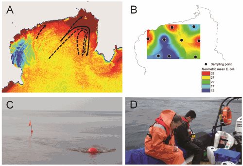
A – Landsat 8 image showing areas with higher accumulation of suspended sediment at surface in inshore and eastern parts of the bay. Drogue tracks represented by dashed arrows. Dye tracks represented by continuous black arrow.
B – Spatial variation of levels of bacteria in shellfish, collected from 9 stations in the bay, are mostly consistent with the spatial variation of suspended sediments.
C – Hydrographic dye tracing and drogue tracking studies provide information on movements of surface waters in the bay.
D – Scientists from Cefas and University of Exeter collecting physical and chemical data to validate the information provided by the satellite images.